


Waterville Caherdaniel

bffcuc
User
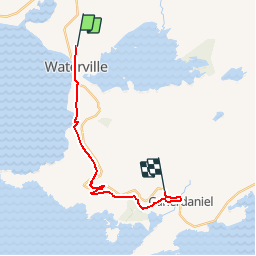

Length
15 km

Max alt
241 m

Uphill gradient
388 m
Km-Effort
20 km

Min alt
6 m

Downhill gradient
348 m
Boucle
No
Creation date :
2014-12-11 00:00:00.0
Updated on :
2014-12-11 00:00:00.0
4h38
Difficulty : Unknown

FREE GPS app for hiking
 SityTrail
IGN / Geographical institutes
SityTrail Plus
The world is yours!
About
Trail Other activity of 15 km to be discovered at Unknown, County Kerry, Kenmare Municipal District. This trail is proposed by bffcuc.
Positioning
Country:
Ireland
Region :
Unknown
Department/Province :
County Kerry
Municipality :
Kenmare Municipal District
Location:
Emlagh
Start:(Dec)
Start:(UTM)
419347 ; 5743356 (29U) N.
Comments